
Allright, I've searched as good as I could, but I didn't find exactly what I was looking for, so here goes my attempt at reconciling everything seen in EoE as best as I can. Just up front: Obviously, the earth didn't split open and neither do we have nuclear winter - so I'll just assume that those things didn't happen.
This is the Blast Radius caused by the explosion after which the Geofront is lifted from the earth. This is based off of the image of the rising Geofront and the display briefly seen, which shows that there is earth excavated around the Geofront by the explosion. Die Diameter is double that of the Geofront, which seems about right. The Image is from NukeMap, generated using a yield of 1600 kt and centering the explosion on Neo Tokyo 3. Given that the diameter of the geofront is 13,75km, and that the display mentioned earlier shows that the Geofront is cleard to at least two thirds its height, and that the only view we get of the Geofront and the crater beneath shows a clean edge, I assume that everything inside the orange circle is neatly chizzeled away, as if a ball-shaped drill was lowered down into the ground.
Given the sea level rise and general disturbances, the crater is connected to the ocean, at least from Odawara to Minamiashigara and possibly at the south-western end near Shimizu. That means that the crater left by the Geofront, and at least part of the crater left by the explosion which excavated it, is filled with seawater.
So, now that the easy part is out of the way, everything after this makes no sense whatsoever. If we assume that everybody returns closest to the point where they died (which would explain why Shinji and Asuka are in close proximity when they emerge from the waves), that means that they are on a beach somwhere on the edge of that circle. After all, they were almost perfectly at the center of the explosion when they died/were tanged. So the question now becomes: Where are they in One More Final?
We clearly see mountains and destroyed buildings in the Water in OMF, which suggest a City. Gotemba is out, it's been erased. The most obvious candidate would be Odawara, since it is depicted as still existing post 2I on the map of Tokyo 3, and likely has high-rise buildings. The other city is Shimizu. Neither of those have any beaches whatsoever, though, and the terrain is pretty rough. So we must assume that the Tsunami following Reis fall did something. Maybe the white sand is ground up Rei that was washed onto the shore.
Now, when GNR died, she squirted blood from her neck into orbit (at least thats what I assume that red ring is we see in OMF). The ring is in an roughly equatorial orbit, as seen in the zoom out from the earth befor OMF happens. We see it from the perspective of Shinji lying on the beach, at an angle. One possibility is that his head is pointing about 20-30 degrees north from the equator, in roughly west-north-western direction. But that would put him right at where Gotemaba once was, so, there shouldn't be any buildings in the water.
On the other hand, if his head is pointing 20-30 degrees south, east-south-east from the center of the explosion, which points at Manazuru. Still, there is no city inside of that, so again, no Buildings should be seen.
The most fitting city to explain what we see is still Minamiashigara, or Oi on the other side of the river, flooded after Third Impact. The white sand could be sediment from the ocean floor, dragged there by the inflow of water into the crater and deposited on the shore.
But if we assume that Shinji is indeed somewhere where Gotemba once was, which best explains the geometry of the ring and the moon, we run into another problem. That place is at 460 meters above sea-level, or 400 to 420 after Second Impact. Given the steepness of the crater walls, there is just no way for a beach to be there.
Eh ... So, yeah. Uhm. Hm. Where the fuck is Shinji?
Post Third Impact Topography
Moderator: Board Staff
Forum rules
By visiting this forum, you agree to read the rules for discussion and abide by them.
By visiting this forum, you agree to read the rules for discussion and abide by them.
- Reichu
- Admin Emeritus

- Posts: 24046
- Joined: Aug 21, 2004
- Location: Sailing for the white shores
- Gender: Female
- Contact:
Re: Post Third Impact Topography
At one point I attempted to figure out where the beach was. I gave up due to the orientation of Lilith's dropped arm -- it makes the combination of vistas, assuming they are all supposed to be from the same general area, impossible. If the shot with the arm were flipped, the problem would not exist, but I verified that the shot was not flipped in post-production or something -- it had been that way all along. I'll try to whip up a crude visual aid later, which will either confirm the weirdness I'm vaguely alluding to, or assure us all that no problem exists after all.
As an FYI: "One More Final: I Need You" is actually the secondary title of episode 26' in its entirety, rather than being the name of the final scene. Good illustration here of why this is actually important and not mere hair-splitting. (The secondary title cards for the two endings, ahem, complement one another.)
As an FYI: "One More Final: I Need You" is actually the secondary title of episode 26' in its entirety, rather than being the name of the final scene. Good illustration here of why this is actually important and not mere hair-splitting. (The secondary title cards for the two endings, ahem, complement one another.)
さらば、全てのEvaGeeks。
「滅びの運命は新生の喜びでもある」
Departure Message | The Arqa Apocrypha: An Evangelion Analysis Blog
「滅びの運命は新生の喜びでもある」
Departure Message | The Arqa Apocrypha: An Evangelion Analysis Blog
Re: Post Third Impact Topography
Edit: Thanks for the heads up regarding OMF, I was just using it as shorthand, since everybody seems to be doing that^^
Last edited by Derantor on Wed Jan 08, 2020 11:41 am, edited 1 time in total.
Re: Post Third Impact Topography
Sorry for double-post, but I feared that nobody would see an edit.
So, Reichu inspired me to try and come up with a landing place for Rei. Here are some pictures.
This time, I just tried to figure out where they are by looking at the beach itself and the coastline in the background. It's not pretty, though. There are clearly islands seen in the background when Shinji has his encounter with Asuka, Islands that don't really exist if my crater size is accurate. If the crater is smaller, as the missing inflow of water depicted in the second picture would suggest, the beach has to be further out to sea, to account for not being able to see Reis head in the final scene when looking out to the water. If we ignore Reis head, then theres an alternative place for the beach in the bottom left corner of the first picture.
Since all of that is rather dreary, I collected some images to help find another solution, mostly concerning Rei's size.
What I find most puzzling about all this is that we are clearly meant to assosciate the location with places we have seen before. The buildings in the water beyond the beach suggest the very first scene of the series, although there was no beach there. The landscape in front of Rei's falling head suggest the place where Shinji fought Unit 03. The gravemarkers look like they are placed in the destroyed landscape of Neo Tokyo 3, as it was in episode 24. The telephone poles evoke the very first scene of EoE - or the general Hakone area.
The absolute worst part of that is that the MP evas are there in the water in front of the beach. Firstly, the water seems very shallow - it barely covers their ankles. Secondly, the Evas are above the Geofront as it rises, and the Geofront rises straight up. Later, they fall straight down - at least the movement and orientation of that scene suggests they do. So... Shinji is right at the epicenter of the explosion. Which would be totally fine, if there was no explosion, no rising geofront, and no hole in the roof of it.
Which leaves really only one natural (and utterly dissatisfying) solution to explain it all: The rising of the Geofront, plus the explosion, were "unmade" by Lilith. I doubt she recreated the Black Moon beneath the ground, so there is just bedrock there now. The beach is ground up petrified Rei, her torso, to be exact. Her head and Arms are humongously large and lie out in the ocean. The shot of Shinji emerging is an optical illusion, suggesting closeness where there is none. He does not emerge from the sea, but from the lake of Lilith-Blood/LCL/Whatever that dripped over her stomach. The lake is not connected to the sea, since Neo Tokyo 3 was at an altitude of 680 meters if we assume 40 meters of sea level rise after second impact.
So, I would very much like to hear your input on this, Reichu (or anybody elses, please don't feel left out). I've got the feeling that I am missing something (other than the obvious fact that we are not supposed to try and make sense of all this, but I like my artsy-emotional-impactful-scenes to be grounded in reality).
Edit: Another tangent: The Red Ring can not be on an equatorial orbit. Otherwise we couldn't see the moon directly behind it.
- ASW_Canuck
- Embryo
- Posts: 27
- Joined: Apr 19, 2020
- Location: Canada
Re: Post Third Impact Topography
Looking at floodmap.net with the depth set to 60 m, having the beach somewhere out on the coastline in the Mishima area would give you a set of islands visible across a bay. The ruins would be the drowned remains of Mishima and its suburbs. The beach could literally be that - sand and gravel washed up by the tsunamis triggered by 2nd Impact, along with the normal beach-building effects of almost 15 years of tides and typhoons.
I also thought that Sagami Bay, with the isolated remains of the Miura Peninsula sticking out of water, would be a possibility. A quick trip to Google Street view determined that you can't actually see the Miura Peninsula from across Sagami Bay.
On a side note, GNR must have had an absurdly low density. She's so large that the Earth's curvature is pronounced when she's entirely in frame, but her body parts don't just crack the planet's crust like an eggshell and turn all of Southeast Asia into a volcanic hell when she breaks up and falls back to Earth.
Edit: Depending upon which screen cap I use, her torso is anywhere from ~340 km to ~700 km long. Her head alone is either ~140 km or ~310 km high. To quote Marvin the Martian, "Where's the kaboom? There was supposed to be an Earth-shattering kaboom!"
Re: Post Third Impact Topography
Ouh, nice, didn't think this thread would gather interest after all this time!
Mishima was one of my candidates as well. Sea level rise seems to be 40m rather than 60m, though, going by the official map of Odawara post 2I. GNR is indeed not bound by normal physical laws - just like the corpse of Ramiel, which remains structurally intact after death. One possible explanation for the white sand I came up with is ground up GNR body-parts; would explain the missing torso and legs. The tides or the inflow into the crater could deposit it on the shore and create the beaches.
That said, I haven't had any success narrowing the location down further. If people don't return at the closest place on a shore to where they died, there are more options, but I think it will be even more unlikely that we find the location.
- Mr. Tines
- Administrator

- Age: 66
- Posts: 21376
- Joined: Nov 23, 2004
- Location: This sceptered isle.
- Gender: Male
- Contact:

Re: Post Third Impact Topography
The results of pulling a 14km diameter sphere out of the crust in the middle of the Hakone region are similarly ignored. OTOH, we do see the impact splashes as bits of GNR fall into the Pacific.ASW_Canuck wrote:On a side note, GNR must have had an absurdly low density. She's so large that the Earth's curvature is pronounced when she's entirely in frame, but her body parts don't just crack the planet's crust like an eggshell and turn all of Southeast Asia into a volcanic hell when she breaks up and falls back to Earth.
Reminder: Play nicely <<>> My vanity publishing:- NGE|blog|Photos|retro-blog|Fanfics &c.|MAL|𝕏|🐸|🦣
Avatar: art deco Asuka
Avatar: art deco Asuka
- ASW_Canuck
- Embryo
- Posts: 27
- Joined: Apr 19, 2020
- Location: Canada
Re: Post Third Impact Topography
60 m is what you're supposed to get if you melt the entire Antarctic ice sheet, but a 40 m increase gives you pretty much the same basic effect. I was working on a writing project, and was trying to figure out what route A&S would have to take to get to somewhere that has food & shelter.
Re: Post Third Impact Topography
That's how I started out as well. Not that that should be any problem in Japan, being as densely populated as it is, with the mountains stopping any tsunami, even giant, from destroying everything for hundreds of miles. The crux of the matter is that there is no way to reconcile the position of GNR's limbs with one another and that there is just too much information missing.
- UrsusArctos
- The Beginning and The End

- Posts: 10501
- Joined: Jun 28, 2007

Re: Post Third Impact Topography
But since most of the mountains in Japan sit along the center of the country and most of Japan's cities sit on the coasts, a giant tsunami would cause havoc and destruction for a large number of people. Maybe not so much in terms of total land area, but in terms of populated area, yes.
(Was Board Staff from Dec 31, 2007 - Oct 17, 2015 and Oct 20, 2020 - Aug 1, 2021)
Not knowing that Monk is bi is like not knowing the Pope is Catholic - ZapX
You're either really bad at interpreting jokes or really good at pretending you are and I have no idea which.-Monk Ed
WAAAAAAAAGH!!!!!(<-link to lunacy)...Taste me, if you can bear it. (Warning: Language NSFW)
The main point of idiocy is for the smart to have their lulz. Without human idiocy, trolling would not exist, and that's uncool, since a large part of my entertainment consists of mocking the absurdity and dumbassery of the world, especially the Internet.-MaggotMaster
- ASW_Canuck
- Embryo
- Posts: 27
- Joined: Apr 19, 2020
- Location: Canada
Re: Post Third Impact Topography
If you look at the size of the splash GNR's body makes, relative to the size of the planet given it's curvature in the shot, there isn't enough water in all the oceans of the Earth to produce waves that big. Her torso is well over a hundred kilometres thick in that shot, and the Pacific Ocean is only about 4 km deep on average.
Trying to retroactively fit a mostly-fictional setting onto a real-world is a a dubious proposition at the best of times when the original creators weren't really trying very hard to do it themselves. I spent about 8 months doing this for a couple of friends' superhero RPG campaign. In most cases all I could do was a rough approximation and just ignore the fact that my post-action write-up didn't sync exactly 100% with what the GM actually described. One session did work, but that was because my grandparents lived in the city the characters were in at the time (Vancouver, BC), and I was literally telling the GM where things were as we were playing.
At some point, all you can do is throw up your hands and declare that in your universe an Evangelion is X meters high, damnit. All the other options will probably leave you huddled under a table beside the broken wreck that used to be series' continuity supervisor, chugging cheap bottom-shelf whisky straight from the bottle.
- Blockio
- Former Moderator
- Age: 24
- Posts: 3840
- Joined: Dec 03, 2017
- Location: vtuber hell
- Gender: Male
Re: Post Third Impact Topography
We're all long past that point

At this point a lot of this is just for shits and giggles, to see how much we can break the established world with real life physics
I can see why Gendo hired Misato to do the actual commanding. He tried it once and did an appalling job. ~ AWinters
Your point of view is horny, and biased. ~ glitz2hard
What about titty-ten? ~ Reichu
The movies function on their own terms. If people can't accept them on those terms, and keep expecting them to be NGE, then they probably should have realized a while ago that they weren't going to have a good time. ~ Words of wisdom courtesy of Reichu


Re: Post Third Impact Topography
Regarding the Aantarctic ice sheet's effect on sea levels, we should all remember that Adam's explosion didn't simply melt the Antarctic ice cap, it annihilated the underlying continental bedrock, which has a rather high average elevation above sea level despite being extremely weighed down by the massive ice sheet above it. The void left behind from taking that much mass away should mostly if not entirely negate the expected rise in sea levels from melting the Antarctic ice cap, and that's assuming that the explosion didn't simply atomize much of the water molecules in the immediate vicinity into free oxygen and hydrogen.
"Our magic is not omnipotent. A little bit of courage is the true magic."
–Negi Springfield, Negima: Magister Negi Magi
"Where there is distress, therein lies a story. Where there is a story, therein lies a will. And wherever there is a will, therein lies a soul."
–Evangeline A.K. McDowell, Negima: Magister Negi Magi
–Negi Springfield, Negima: Magister Negi Magi
"Where there is distress, therein lies a story. Where there is a story, therein lies a will. And wherever there is a will, therein lies a soul."
–Evangeline A.K. McDowell, Negima: Magister Negi Magi
Re: Post Third Impact Topography
"Atomise" does nothing to mass, though. Unless stuff gets blown out into space, the mass of the earth doesn't change. Pulverising Antarctica could even increase the sea level rise when the remains fall into the sea. Since the map showing the sea level rise puts it at roughly fourty meters (which is already a tad below the estimated rise in sea level), I assume that at least some stuff was blown off into space.
Re: Post Third Impact Topography
Sure, if you're counting the atmosphere. My point is that the oxygen and hydrogen would be stuck in the atmosphere, since their natural atomic state at the temperatures found anywhere on Earth outside of very specific lab equipment is gaseous. How reactive are the two elements when mixed together at natural atmospheric conditions?
Pulverising Antarctica could even increase the sea level rise when the remains fall into the sea.
And how long would that take?
Since the map showing the sea level rise puts it at roughly fourty meters (which is already a tad below the estimated rise in sea level), I assume that at least some stuff was blown off into space.
See, I looked at the map, and I couldn't understand what it's supposed to be indicating. Obviously it's a part of Japan, but there's no clear indicator of where the new coastline lies, and which areas have become submerged.
"Our magic is not omnipotent. A little bit of courage is the true magic."
–Negi Springfield, Negima: Magister Negi Magi
"Where there is distress, therein lies a story. Where there is a story, therein lies a will. And wherever there is a will, therein lies a soul."
–Evangeline A.K. McDowell, Negima: Magister Negi Magi
–Negi Springfield, Negima: Magister Negi Magi
"Where there is distress, therein lies a story. Where there is a story, therein lies a will. And wherever there is a will, therein lies a soul."
–Evangeline A.K. McDowell, Negima: Magister Negi Magi
- ASW_Canuck
- Embryo
- Posts: 27
- Joined: Apr 19, 2020
- Location: Canada
Re: Post Third Impact Topography
And how long would that take?
It would be a very slow reaction, hydrogen's autoignition temperature is 500 °C and it would rapidly dilute below its lower explosive limit of 4%. In any case, any event that is energetic enough to accelerate a statistically significant portion of an entire continent to escape velocity is, shall we say, a "total party wipe" for Earth's biosphere. No fussing about with anti-AT fields and the like, just set the entire atmosphere to "broil" and watch the nasty LCL-based interlopers cook in their own juices.
Floodmap.net will give you a very good idea of what is and isn't underwater, you just set the water depth and browse around like in Google Maps. There is also a small back-of-an-envelope doodle from Gainax that roughly shows the flooding levels east of Tokyo-3, but there are some very obvious inaccuracies in it (i.e.: Odawara is very low-lying, and should be nothing more than an inlet protruding off of Sagami Bay).
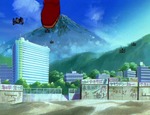
Drifting back to the earlier discussion regarding the location of the beach in EoE, the sandy beach that Shinji and Asuka fight Israfel on is located just up the coast of Suruga Bay from Mishima, probably on the eastern outskirts of Fuji City. You can see Mt. Fuji in the background of this screen cap from Episode 9, with the lower hills between Hakone and Fuji to the right (east) and closer to the foreground. You can get a pretty good reproduction of this view in Google Street View on the Numazu Bypass just east of Fuji City. The remains of buildings can be seen poking out of Suruga Bay, so the beach is something that has come into being since 2nd Impact.
Re: Post Third Impact Topography
Good thing we know that the "explosion" was actually caused by Anti-AT Field hax rather than anything physically "natural". In any case, it proves my secondary point on that subject: It's quite likely that Earth genuinely lost much of the mass that formerly comprised the ice and bedrock of Antarctica.
Floodmap.net will give you a very good idea of what is and isn't underwater, you just set the water depth and browse around like in Google Maps. There is also a small back-of-an-envelope doodle from Gainax that roughly shows the flooding levels east of Tokyo-3, but there are some very obvious inaccuracies in it (i.e.: Odawara is very low-lying, and should be nothing more than an inlet protruding off of Sagami Bay).
This seems to support my theory that there's more to the submergence of areas like Old Tokyo and Yokohama than a higher global sea level; namely, that the nuke(s) that struck Old Tokyo and the 2I-induced earthquakes that ravaged Japan ultimately caused massive soil liquefaction/subsidence and landslides under cities like Old Tokyo and Yokohama.
Hell, if we look at the bird's eye view of nighttime Japan from Episode 6, the only clear discrepancy from real-life Japan's topography that I could see is that the Tokyo Bay is conspicuously wider than it should be - specifically, the areas that should constitute the "heart" of real-life Tokyo (which is really a metropolis extending quite a long way inland) and the city of Yokohama should be where the western quarter/third of the bay is in that screenshot.
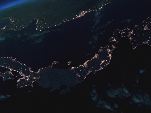
Incidentally, Rebuild's rendition of the same scene portays Tokyo Bay with its real-life boundaries, though the area of Old Tokyo appears conspicuoulsy devoid of light in contrast to its surroundings (the blackout starts from much farther away and proceeds progressively towards the center of the country, so it can't be that).
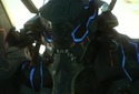
Drifting back to the earlier discussion regarding the location of the beach in EoE, the sandy beach that Shinji and Asuka fight Israfel on is located just up the coast of Suruga Bay from Mishima, probably on the eastern outskirts of Fuji City. You can see Mt. Fuji in the background of this screen cap from Episode 9, with the lower hills between Hakone and Fuji to the right (east) and closer to the foreground. You can get a pretty good reproduction of this view in Google Street View on the Numazu Bypass just east of Fuji City. The remains of buildings can be seen poking out of Suruga Bay, so the beach is something that has come into being since 2nd Impact.
For reference, this is a shot of Eva 02 after it bisected Israfel shortly after encountering it in the waters of Suruga Bay, with the ruins of modern buildings around them.
"Our magic is not omnipotent. A little bit of courage is the true magic."
–Negi Springfield, Negima: Magister Negi Magi
"Where there is distress, therein lies a story. Where there is a story, therein lies a will. And wherever there is a will, therein lies a soul."
–Evangeline A.K. McDowell, Negima: Magister Negi Magi
–Negi Springfield, Negima: Magister Negi Magi
"Where there is distress, therein lies a story. Where there is a story, therein lies a will. And wherever there is a will, therein lies a soul."
–Evangeline A.K. McDowell, Negima: Magister Negi Magi
Return to “Evangelion TV Series + EoE Discussion”
Who is online
Users browsing this forum: No registered users and 2 guests